Translate

|
Walkers & Hikers Groups
|


| + loop S. round escarpment. Snow walk. 16.87 Km, 3h:13m (excluding stops); Average Speed (excluding stops) 5.2 km/h; Max Speed 6.7 km/h; Total Ascent 102m (including very steep uphill start !); Total Descent 146 metre. |
GPS Stats From Frank: Distance 12.17 km; Duration 2h:18m:35s; Average. Speed 5.3 km/h; Max. Speed 7.0 km/h; Total Ascent 99 m; Total Descent 86 m;
 |
GPS Stats & Pic. From Frank: Distance 14.16 km; Duration 2h:40m:31s; Average. Speed 5.3 km/h; Max. Speed 7.5 km/h; Total Ascent 188 m; Total Descent 178 m; |
Route:
- From South West end of Schäftlarn S- Bahn platform, a new route East to valley, crossing then joining Kloster- Str shortly before the Kloster,
- Down through the middle of beer garden at Kloster Schäftlarn to avoid traffic,
- Across the road bridge, to beer garden on
right = South of road adjacent "Gasthaus Zum Brucken-
Fischer", by river for a drink & to watch the
swollen river. (Other pictures of
river last week further downstream at Munich).
Would have been nice to eat too, but a long way left to
walk,
One joked we could have lunch & take the bus back up the hill, Tempting .
. - (We stopped short of 2nd bridge East across the Isar- Kanal).
- Return back West = left across bridge
-
South South West along the raised
embankment.
- (Not the immediate fork South East back to river bank, path then going South, as that would be a longer route & perhaps too wet).
- The Compass map wrongly shows the 2 tracks meeting road at different places whereas they actually merge before connecting to road. What we saw can be seen on maps . google . com. (Maybe things were different prior to that concrete bridge, but that bridge has been there as long as I remember, & map not that old). )
- A field away from the West side of river, path headed South South West;
- After field on right=West ended, continued South West, through forest,
- Across field to rivulet (direction South) under trees where path became water logged, boots & socks off, barefoot through clear water ~ 20cm above muddy rutted track;
- South West through 2nd longer field, it remained too wet, so before path slanted West into forest,
- Up hill North West on a minor track that shrank to a trickle of water on stones.
- To top of valley, left
-
Section Uncertain needs
checking.
- Along West South West, &
- Left = SW down a track turned out to be a dead end forestry track, it was too steep & too far in raw forest to consider going down.
- Back up again; Then left = North West,
- Turning Left = South West, perhaps on to Gregor Weg ?
- Then on some path (I can't see on map), Down to the river on a long oblique along the side of the hill,
- Path parallel to river, then became steep up hill steps.
- Thunder & lightning on the way up, then pouring rain, (we remembered the earlier joke. )
- Another forest track down, that degenerated to nothing but raw forest.
- Back to near river level, we found a path, no way to know Isar was near, (where I remembered a path should be), except that a GPS phone told us we were near the river (maybe we'd have heard or seen it if it hadn't been raining so hard).
- A long walk on path (first bit submerged again), later much of which had clearly been washed by River recently (river was a few metres adjacent, about 1 meter below path),
- At turn off right, uphill to Icking in pouring rain, two were tempted. Leader pulled out plastic encased map, but too wet to focus & no glasses, & knew the river route not the inland route, & we didn't know how far to Icking S- Bahn). GPS- phone map not consulted (owner had displaced contact lens from excess rain).
- Stopped briefly at Weir (with fish ladder on near = West side, & (un- noticed as so wet), Isar Canal starts on East side). Someone suggested we could cross & walk other side, but we did not as that would have been a much longer route (via Puppling, to a bridge to cross Isar, to get to Wolfratshausen on Loisach)
- South West to where, North of Pupplinger AU, the river Loisach on West joins river Isar on East.
- Stone path by S Bahn rail track, Saw a small less than 1 metre wide subsidence off rubble from rail track on to path (we travelled back along that track later),
- South Underneath modern concrete bridge of S- Bahn.
- South past raft launch point
- South past 2nd raft launch point
- South past pub Gruener Baum on right=West,
- Left=East Crossed green metal road bridge of Weidacher Haupt- Str
- At East bank, Immediately South along East bank of river Loisach,
- Past Bahn- Hof- Str bridge,
- Past car park (with fun fair in rain with no customers),
- In to adjacent pub with beer garden "Wirtshaus Flosserei" in, all of us soaked, for a well deserved hot meal.
- North then East on to Hammer- Schmied- Weg to Bahn- Hof
(If we'd taken up the earlier suggestion of lunch at "Gasthaus Zum Brucken- Fischer", we might have had another 80 minutes walk in the rain before arrival, if we hadn't cut short.)
Map: "Alpen vereins karte 7/1 1:25 000, Tegernsee Schliersee"
Organiser: Julian .
Route:
- SW to lake
- W. round lake
- Left=South,
- Past HVB back gate,
- Right=West, Up slope along contour of Freuden- Berg,
- Past Eis- Platz on right,
- Left=South along edge of rail cutting,
- Right=West Over BRB rail foot- bridge, (last look at lake view)
- Along Tegernseer Weg to T junction with Wester- Berg- Str,
-
Here, (as last time with Omar & Co, seeking a
direct route) We did this diversion, same as last
time:
- Left=South,
- Right=West past building, into timber yard
- Right=North through timber yard
- pedestrian gate @ far end fortunately not locked
- Through & left = NW on to Tegernseer Weg
- Next time (2013-10-27) we should go Right=North, briefly along Wester- Berg- Str,
- then veer left = NW on to Tegernseer Weg
- 2nd Left (on juntion offering 2 lefts), SW uphill along Breiten- bach- str (not flat along Tegern- seer- weg)
- Past small lake/pond on Right.
- past Krains- berg on left, not taking Left=SE turn AV W10.
- Continuing SW parallel to Breiten- bach stream, along Hennerer Str,
- Past Rodel Bahn on left.
- Up to Hennerer Car Park on left.
- Uphill NW Past car park on left
- The off road ascent started here.
- (The bergfex . de + david.f/2013-08-31 route diverges from the car park, they follow the valley SW, an easier lesser set of gradients then take Prinzenweg around Kreuzkopf (the other side of which was a problem heading to Kreuzberg Alm. (which they reckon takes an hour -proof of easier gradients that way))
- NW up, SW along contour, W, NW steeply up AV (Alpen Verein) Wander weg/Steig W9 through Schilchen- tal to Gindel- Alm- Schneid (which is a bit S & down from Gindel summit 1271m)
- ( The bergfex . de + david.f/2013-08-31 route passes here later coming from South. Then they go West flat to Neureuth,then down Wander weg N via Lieberhof to Tegernsee. )
- Choice of 2 (or 3 possibly?) Alms, Stopped for a
drink on the Right uncrowded nice view of Schlier- see,
Met an organiser of AV @ Alm going the other way, who
said next Alm would be a lot more crowded (but he &
Elena were thinking of Neureuth, the short way, too
short, not the planned route )
- Drink @ Alm
-
To avoid normal steep walk SW up bog-ish hill:
- West a bit along AV N2
- then up SE
-
Down shallow then steep
{** Diversion to try next time: Half way down the steep, & also at base before steep rise to Kreuz-berg hut, google maps satellite view shows 2 paths veers off to left = SE, which next time would seem to allow one to avoid surplus down then up past Kreuz-berg & down.
- SE Up steep path to Kreuz-berg with alm (didnt purchase, just sat on logs round the back (where no view of Schliersee))
- ( The bergfex . de + david.f/2013-08-31 route at this point is same path as ours, but opposite direction. )
- W,S,E down 4 wheel vehicle track
- Veer off right = South down steep field, off track, (harder on knees but quicker) rejoining same track (that headed E then SW) heading down SW at first T junction with Prinzen- Weg
-
A sign there points SE, marked:
- Henner 45 685
- Schliersee 1 1/4 685
- Maybe 20 metres SSW slightly down to next junction with footpath up SSE
-
Signed in yellow background & black font:
- Baum- Garten- Schneid 1444 1 1/4
ueber Sag- Fleckl. - Rieder-stein 1207 2H
ueber Baum- Garten- Schneid - Galaun 2 1/2
- Baum- Garten- Schneid 1444 1 1/4
- 4 dropped out, (Un-related to next bit, just had
enough
).
They disappeared SSW down AV vehicle track N2. - Problem Solved 2015-05-10
We 3 (marked *) continued SSE up AV footpath N2 toward Kreuz- Berg- Koepfl -
- It curves right = SSW up then flat, (a steep drop to right, not for people with vertigo).
- Then the path just seemed to end !
- We couldn't figure where it had gone before, all seemed pretty much raw forest.
- We turned back! So failed to reach Sag-Fleckl (Julian had planned after that to continue on to Baum- Garten- Schneid, then Rieder-stein as on a previous hike).
- Julian had used it previously (with Omar & co. I recall ?), & we met other older hikers who reckoned they'd used it 20/30 times before & planned to go up where we'd just come back down, but the path just was invisible).
- Looking at maps . google . com after did not help, as their pictures were oblique & were taken in summer, leaves on trees.
- 2015-05-10 there was a path faintly discernable, & with LK confident where we going, we got through.
- We reverted to SSW down AV vehicle track N2.
- Left = SE, then SW along long boring wide stone vehicle track, over a kilometre below & past Rieder-stein (above on left)
- Up, S, E, S to Galaun in maybe 5 or 10 mins,
- Drink at Hut (nice view of S. end of Tegernsee lake) Drinks more expensive than Gindel- Alm- Schneid someone said.
- (Omitted to go up to Rieder-stein chapel.)
- Return West across small plateau, & first left, a slightly different way than up, not shown on AV map, but joining back to same boring stone road
- *** Back along same Boring road WNW, N past previously where we'd joined, West past Hubertus Huette along AV N2 parallel to Alp-bach stream. A giant long loop fit better for vehicles, not hikers who can also go up & down !
- Previous *** decision was discussed & agreed by all, but looking at map more since, it would have been 3 x shorter & more interesting had we gone North on AV T4 by Rieder-stein Holz, Auer-bauer AV T3, & would have emerged somewhat nearer Indian.
- Left = South to Indian meal outside @ See Str 7
- Leisurely stroll South + West down to lake & benches
- North along lake;
- East up to road
- North to train un-crowded both directions .
The
bergfex . de + david.f/2013-08-31 route seems a
somewhat shorter version of ours, particularly with our
extras, & the up gradients seem gentler (from the
map),
bergfex . de route quotes stats: { 14.6 km Duration
3:00 Up 690m Down 742m Max. Height 1,324 m Min. 737 m }
We didnt have GPS equipment with us to measure ours. The
Duration 3h seems a lot less than we took on a steeper
ascent & longer route on a hot day, but our real time
perception also includes break times at peaks & Alms
! ![]()
Announced as: This will be a walk of about 10 - 12 km along the Auer Mühlbach, beginning just south of Kolombus Platz and continuing along the shores of the Izar to Großhesselohe stopping for a drink, etc. probably at the Waldwärtschaft beergarden. We will meet at the Bushaltestelle just outside the western U-Bahn exit at Kolombus Platz on Humboldstraße at 2:30 Sunday the 1st of September. If you are arriving on the U-Bahn please take the Plarrnerstr. - Bus 58 Silberhornstraße exit. My cellphone number is ....
Julian arrived by bike just after they'd left & raced round country on bike trying to find them, and joined at beer garden
Announced as: Easy walk about 2 hours up , break at a nice panorama view cafe. Meeting 09.45 at Hauptbahnhof at the ticket counter for the BRB Bahn

Picture is coming down after lunch, where we joined a road. left to right: Marion, Elke, Astrid, Helga H (leader), Stephanie, Cornelia, Birgit, Julian (behind camera). In the valley we split, 4 took the train, 4 of us walked to other side of valley, then SE back to Bayrisch Zell for ice cream & then the BRB train (full later, but no one standing in our part). Another walk where by chance Julian was only male & English, & all the rest female & German, though we chatted in both languages, so what's happened to all the men we wondered ? I've since been told the Denkmal schutz opening of monuments that day included rare opening of bomb shelters - Maybe real men were all down bomb shelters & inspecting ? -) . PS all non smokers again, as usual. Other larger higher quality pictures off line.
- Miesbach 09:10 Cornelia
- Seefeld-Hechendorf.Herrsching-Andechs-Herrrsching :
12:00: Julian


- Walk, Cornelia, 11km, 110m, + optional 8km & 300m to Fischbachau
-
Hike, Julian,
Schliersee to Tegernsee via Sagfleckl (1154), &
Gindelalmschneid (1330) & Indian restaurant @ lake
Tegernsee.
- Same start as 2013-08-18 ...
- Up past Hennerer Car Park on left.
- Before the pub: Left continue following the valley, (Not right on W9 to Gindelschneid.
- South West up Stradel- Tal to junction.
- I turned right onto path W9, going N then NW anti clockwise on Prinzenweg, around Kreuzberg- Koepfel.
- To have allowed us to check the Puzzle from 2013-08-18, I could/should instead have gone left South then West to Sagfleckl, to allow us to then try N2 clockwise round Sagfleckl - So the mystery remains!
- After exiting Prinzenweg I took Omar & at least 1 other from the group 15 metres South West, to see the Puzzle from 2013-08-18, but we did not go up & try & solve it (As one of the group had gone ahead alone up toward Kreuzberg)
- 1st Mountain hut (Kreuzberg) was closed (as of 1st Oct, a man inside, but marked Private).
- 2nd (Gindelalm) 2 were open, ours (Southern one) was open for last w/end, & ran out of of dunkles beer, kaiser schmarn, some cakes etc.
- 3rd, Neureuther was open (as expected, near Tegernesee) but we didn't go in.
- The track (named as Winter track) I chose (largely 'cos it would deliver us near right part of Tegernsee for Indian + weather was beginning to fail) starting just short (East) Of Neureuther that heads South was steep wide fast, slippery grit, boring, obviously the supply route for vehicles, next time we'll probably try one just after (West) of Neureuther), though the contours show it (later them) as even steeper, some are real rock foot paths, not gravel vehicle track/road.
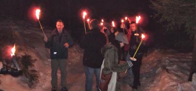
Frank's smart phone informs: total 18.94 km, traveling 3:37 h, (5.2 km/hour) ascended 439 meters, descended 438 m, average temperature of 17, humidity 51% Torches were used for descent.
12.7 Euro up ticket only, to openstreetmap . org / node / 914332319 Gulasch soup & mineral water at top. Walked higher toward probably Rohrkopfen, till near it was clear the last bit would be more like mountain climbing. L & I turned back, joined R , back past cable car restaurant & mountain hut, L leading South West, mostly down hill, probably past Tegel- Berg- Kopf 1567 m. A bit rougher hike & bigger rock steps than some others, so R with shorter legs and a dodgy heel found those jarring. 2 or 3 U shape steel steps in the rock added to the interest.
Maybe 3/4 down we passed some adventurous young chinese tourists heading up in tennis shoes, but too late in day, & they didnt know what was up there, so I told them a cafe in maybe an hour & a half or more, but best return down this route before dark. L later pointed out as they were going Up & my time estimate was from Down, & last lift down is 5ish, they better had to have turned round.
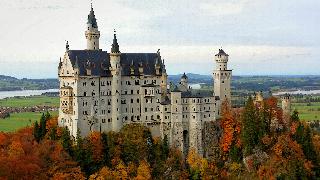
After (guessing) 2 or 3 hours took us down to bridge of cast iron frame + heavy wood beams over the gorge South of the castle. The bridge Melanie & Phillip know, it was swarming with tourists.
Left R by castle with bad heel to descend slower along road, & L & I walked most of another hour or so, fast & hot, back to car, hot boots off with relief! & drove back to pick up R , returned near car park in direction Munich; Paused hoping to see if sun would move round a mountain & illuminate Neuschwanstein as people with tripod cameras were hoping - it didn't.
Perfect weather, we all 3 took lots of pics. Easiest way to take similar pictures is to park in valley under castle, walk up road (closed to cars) to iron bridge, then hike up stone path another 30 or 40 mins. Trees obscure view except on 3 to 5 or so bends near edge of cliff. A few tourists & tripods cluttered & cramped view on lowest bend.
Good that L planned the hike as up via cable car though, it was enough.
Passed a Greek Taverna on Right = South a few Km after leaving. Seemed too soon to stop. After that it seemed Bavarian.
Stopped half way home in old walled town of Schongau
- www . openstreetmap . org / relation / 936750 # map = 13 / 47.8125 / 10.8939
- en . wikipedia . org / wiki / Schongau , _Bavaria
- de . wikipedia . org / wiki / Schongau
Next time in Schongau, we'd try the up market burger joint we first fancied: Bistro Ballenhaus
D ropped off L then R at flats, & back home maybe 10 ish.Left car in Neuhaus railway station car park, took bus (3.80 EU/person von 97029 Neuhaus Josefstal, nach 97065 Spitzing/Bleckstein) leaving from there {10:11, 11:11, 12:11, 12:19} going uphill to saddle point. About 9km long. Total 757m up and 812m down. google . de / maps /... Hike quite demanding, 2 or 3 sections with wire rope. Definately a boots hike. Sandals or soft treking shoes Not appropriate.
Webcams
- neureuth . com /#webcambild
- tegernsee . com / service / webcams - in - der - ferienregion - tegernsee . html
- wallbergbahn . de / en / webcams/
Next Walks & Hikes
- Future dates where/if known/ listed, are subject to weather & whim.
-
Future ideas:
- www . europeanwaterfalls . com / waterfalls / laintal - wasserfall/In Jachenau there is a parking from which the trail starts heading north along the river Große Laine towards the Lainalm. The walk takes about 2 hours (5 kilometer) and has an ascend of 160 meter. The river Glasbach drops down, in three stages, over 40 meters with the highest single drop of 15 meter.
- join to mail list to get announcements & updates.
-
Some hike ideas (from Lisa)
- BRB + bus to Spitzingsee, walk to Rotewand and down to Bayrischzell.
- Or BRB + bus to Spitzingsattel, walk up Bodenschneid and back to Spitzingsee, or (long walk) Tegernsee.
- For a quick walk, Wallberg. Easiest to do with cars as the bus from Tegernsee doesn't run very often.
- PS from Lisa re. 14 Nov 2017: all Gindelalms shut,
but Neureuth open. One of the Gindelalms often opens even
in the Winter, if good weather and weekend or bank
holiday. the Indian restaurant in Hausham opposite the
Bahnhof has closed down, but it was pretty average. The
one in Tegernsee which was excellent looks closed down
(black plastic covering the windows inside, but all the
signs are still up and there was a delivery outside the
door of what looked like a big new catering cooker, so
fingers crossed they are just refurbing.
Webcams: wallbergbahn . de / en / webcams/
tegelbergbahn . de / webcams . html
- If you want a walk/ hike next weeend, & the organisers haven't announced one yet, then Mail The Organisers to encourage them.
HBH: Default venue to start walks is often: 12:00 at Haupt Bahn Hof = Main Rail Station, pedestrian concourse, ( 1 metre above external pavement level), outside news agents "International Presse", in main hall (not Starnberger & not Holzkirchner Bahnhof) about 20 metres South into main building, from the North exit of Main rail station building where it joins taxi rank of Arnulf Str. Beyond end of (approx) platform 23.
- Ski Trips In winter months.
- Fackel Wanderung (Flaming Torch walk): Ask Richard/ Frank/ Julian.
- As well as mountain, country, fast & long walks, & walks to a monastery etc, we also do shorter walks, some in country, some in town with a commentary on local history, & some eg from a U bahn in the English Garden (a park) to a Beer Garden.
- Walks are announced to the mail list
- Other sports (& indoor) events get announced on general mail lists.
- Fancy a beer garden in Munich Friday/Saturday evening ?
- Events are organised by unpaid unqualified
volunteers.
Participation is at your own risk and your own responsibility. We disclaim all responsibility. If you don't like that, do not come. - No children ! Adults only. Local laws says too much about burdens of responsibilities of organisers, events & kids. We're not paid, not motivated, & not interested to shoulder your family responsibilities. We also discuss adult topics & words that don't interest or not fit for hearing by kids, & we're not interested in remembering all day to avoid that. Don't bring kids.
- Pictures from some walks.
-
Please volunteer to lead a walk;
- You do Not need to be fast!
If you're slower, that would suit some, particularly beginners & irregular walkers. We have some normal walk, & some fast & long walk leaders, but we're short of leaders for shorter & slower walks! (Perhaps because regulars speed up ?) - You do not Need to be able to use a compass
!!!
You can alone organise a walk, or share organising it with someone else. (eg sometimes one person is good at email, another is good with a compass). Just be absolutely sure which of you will do all of these: { Send email announcement; organise tickets; head counts; choose a route on map, considering distances & obstacles; navigate (being able to also use the sun if no cloud, or a compass, and Not relying just on GPS that could fail if eg battery fails, it gets dropped, rain or river water ingress-es etc); select plan & find the right stages en route, deal with emergencies, & capable to speak English & German (for walkers, farmers, ticket inspectors, travel disruption announcements) (not essential, just nice, as most of us can speak English & German, but remember we sometimes have people whose native language is neither English nor German) } . - Contact Author or Organisers.
- You do Not need to be fast!
The Fast, The Slow, Wimps, Moaners & The Clueless ;-)
No Stops En Route - If announced
"Brisk Walk" - If announced
If you will not walk somewhat faster than normal, you will be a problem to yourself & the group. Brisk is not a relaxed ramble!
"Fast Walk" - If announced
- Expect a fast or tiring long walk !
- If you walk at a normal speed, you are Too Slow, do not come ! Expect to be left behind, to find your own way back. Bring your own map & compass to find your own way, alone.
-
We aim for a combination of eg fast 3 hours non
stop, or minimum 15km to perhaps 20+ km.
(I blush at defining "Fast" at these low numbers, as real long distance pilgrims going eg France to Spain used to walk maybe 25/ 30 km between stops ? & armies march/ yomp long distance with heavy loads on worse terrain than us leisure walkers)
- Only about 15% of our walkers enjoy the Fast walks.
- Normal walkers would be uncomfortably stressed/ the fast walks.
- We occasionally throw in a few extra kilometres en route for a nicer view, a better route or a better pub, etc. It may be discussed en route, moaning is bad form.
- Fast walk organisers & walkers will not change plans & slow speed for a slow walker.
- Are we trying to scare off all but Fast people from
walks announced as Fast ? Yes, Of course ! Best to have
a matched group, not disparate speeds !
- Not all walks are Fast. Go on a normal one first if in doubt.
Moaners
- If you will not or can not walk according to the announcement, eg "Brisk", "Fast", "Non Stop" whatever ... ; Do not come; stay home, or go on or organise some other walk. Do not try to degrade a walk by slowing us down/ diverting or limiting us, or moaning.
- Organiser's wishes out rank moaners by far. If in doubt do not come.
- Become an Organiser if you want some other walk format. Organise, announce, plan, navigate, & lead a walk of your preference. Our mail lists, web etc available to help you organise walks, (In particular we could use more organisers of slow walks.)
-
Moaning About Speed & Wanting Rests.
-
Inexperienced people sometimes assert we should all
go slower for some slow person, or we should divert,
pause, or shorten route etc: No ! - Wrong
!
Organisers & fit regulars know from experience:- There's too often someone slow at the back, risking losing us, potentially slowing us down.
- Slow people if accommodated, encourage more slow people, on that walk or future walks.
- Walking groups that slowed a bit each week, have before ended up far too slow.
- Fit walkers need & rely on leaders to keep the pace up.
-
Inexperienced people sometimes assert we should all
go slower for some slow person, or we should divert,
pause, or shorten route etc: No ! - Wrong
!
The Clueless: Guess What ... What a surprise ;-)
-
Wimps: Realise There's Mud In The Country !
Don't moan that you don't want to walk on mud ! We really dislike walking on roads. We walk on muddy paths & across fields without complaint, in preference to near smelly, noisey or busy roads, or even empty roads, as tarmac gets hard & boring.
Note some organisers do walks in the park, there you may get tarmac.
Some organisers also do mountain hikes too
Some organisers also do skiing & water sports, & bike rides to beer gardens too.If you want tarmac in the country, do not join us, Use a path in a park in the city. We will Not all walk on tarmac because some wimp wants a quicker cleaner route to the luxury of a toilet in a cafe, or to take a short cut to a railway station to rush back to Munich. (We even had a fool in stiletto heels once, who got sent home at the start That's why this page sets
out to help some people learn if there is a mis-match
of expectations, Before they arrive in the field. )
-
No Toilets !
More Info
- If it's 10C in Munich, at 2,000 metres equivalent is +0.46 C. (but that'd be in air over Munich on the plain, I guess well into Alps mountain range, surrounded by other mountains, it'd be colder than a singular 2,000 m. mountain on the edge of the Bavarian plain, or a plane over Munich).
- International standard atmosphere rule of thumb, it's
2C colder every 1000 feet vertically you go.
(6.49 K(°C)/1,000 m (3.56 °F or 1.98 K(°C)/1,000 Ft) ) -
Munich altitude: 530 metres
- 1 metre = 3.2808399 feet. 1 foot = 0.3048 metre
- 530 m x 3.2808399 = 1,738.8451470 feet.
- 10 - ( (2000 - 530 ) * 6.49 ) = 10 - 9.5403 = +0.46 C.
schwangau . de / aktivitaeten / wandern - und - klettern/
Knees
- PS A clip from email: I need to lose some weight both off of me & out of my backpack. Hiking sticks can cushion steep descents & protect knee shock. They are a damn nuisance to other people walking nearby though, be aware, But very useful if someone in a group has some, in case someone does something to a knee & needs to borrow 1 stick.
- See Also: ../ski/#knees & ../bike/#knees